Simultaneous Localization and Mapping (SLAM)
& Indoor 3D Laser Scanning
Real-time 3D mapping and localization in GPS-denied environments using SLAM technology.
Local Accuracy
1 - 2 cm (Survey Grade)
Scanning Range
Up to 120m Range
Point Speed
650,000 pts / sec
Positioning Link
RTK GNSS + Visual SLAM
Indoor & Underground 3D Mapping
Simultaneous Localization and Mapping (SLAM) is an algorithmic system that allows scanners to track their motion trajectory while building a 3D laser profile of the environment. Unlike standard aerial drones that depend on GPS, handheld SLAM instruments utilize laser sensors and IMUs to maintain positioning, mapping enclosed spaces with high local precision.
By matching overlapping features and implementing loop closure loops, SLAM algorithms filter out trajectory drift, delivering clean 3D coordinate grids.
Simultaneous Mapping
LiDAR scanners measure surrounding shapes in real time while tracking motion profiles, compiling 3D coordinates without needing GPS signals.
Loop Closure Calibration
Re-visiting previously scanned positions automatically calibrates path drift parameters, adjusting coordinate data accuracy.
RTK & Visual SLAM Integration
Combines visual frame tracking, IMU records, and geodetic RTK GPS targets to tie indoor point clouds to absolute coordinate positions.
SLAM Handheld Fleet
We operate visual SLAM scanners and real-time edge processing units to map complex environments.
CHCNAV RS10 Handheld SLAM
A professional visual SLAM scanner. Features integrated RTK GNSS targets, dual panoramic visual cameras, and active laser rangefinders. Links global coordinates with indoor spatial scans seamlessly.
Share S10 SLAM Scanner
An ultra-portable handheld mapping system. Processes scans in real-time on local edge processors, enabling rapid stockpile calculations inside warehouses and structural inspections of vertical assets.
SLAM Deliverables
We process SLAM point cloud data into industry-standard CAD and BIM models.
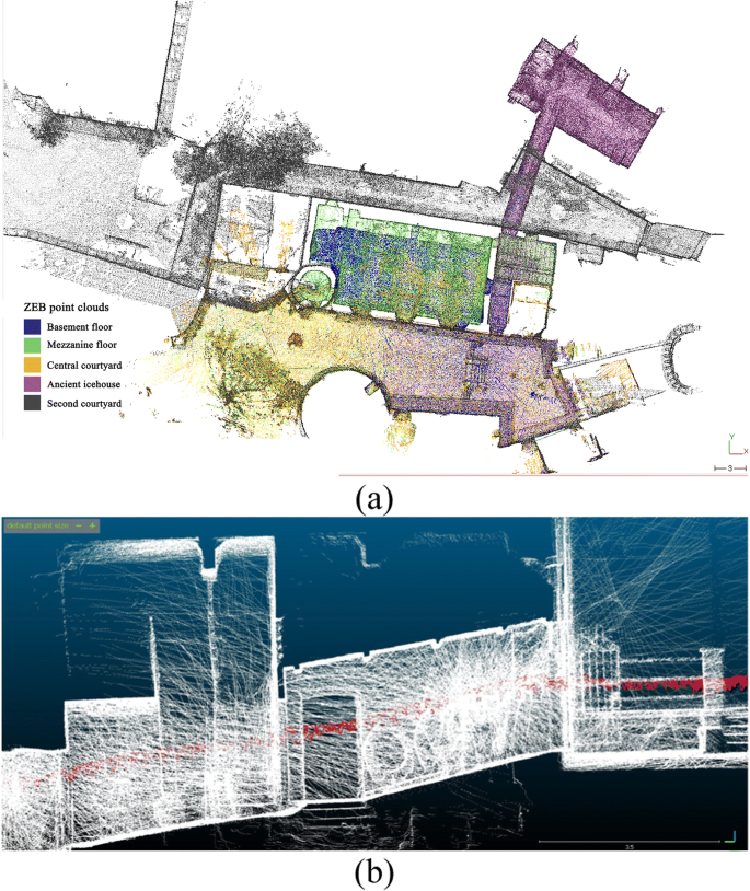
Airborne & SLAM Point Cloud Fusion
A seamless, hybrid 3D dataset merging high-altitude UAV LiDAR scans with terrestrial handheld SLAM records. Eliminates spatial data gaps by combining roof canopies and outdoor topography with interior layouts and underground spaces into a single, unified coordinate system.

CAD Floor Plans & Layouts
CAD drawings mapping structural columns, walls, and boundary layouts, compiled directly from the SLAM scan coordinates.
3D BIM Models (Revit)
Parametric 3D Revit models built directly from the SLAM scan coordinates. Speeds up building inspections and facility management.
Volumetric Stockpiles Survey (Sheds)
Calculates the volumes of stockpiled materials (ore, minerals, grain) stored inside closed hangars and warehouses where drones cannot operate.
SLAM Industry Applications
Applying handheld spatial laser scans to map coordinate locations in enclosed environments.
Underground Mining
Mapping tunnels, shafts, and stockpiles where GPS signals cannot penetrate.
Building BIM Audits
Rapid scanning of indoor layouts to map structural dimensions and compile BIM databases.
Stockpile Sheds
Measuring stockpile volumes inside industrial warehouses and silos.
Forestry Biomass
Walking scans measuring tree trunk heights, branch volumes, and forestry inventories.
Ready to Map Enclosed Sites?
Discuss your surveying needs with our technical team. We provide tailored solutions and accurate estimations.